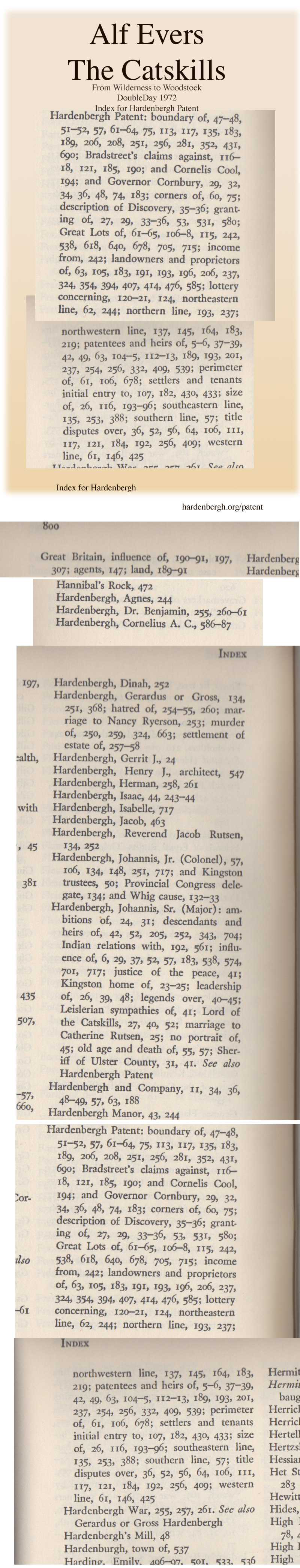
The amount of information in The Catskills: From Wilderness to Woodstock, by Alf Evers is so astounding that see no huge reason to try to retell the story. I put the relevant index from that book on the right.
I copied the short version below from the Miller book. Here is an article from the Olde Ulster History, May 1910: The Hardenbergh, or the "Great" Patent and the OCR from archive.org and the page images from scribd.com.
If you have any maps of the patent, or other references you think should be mentioned here, drop me a line, as Thomas Soja did with this Great Research on the Hardenbergh Patent, including the 1749 Wooster Map!.
From THE HARDENBERGH FAMILY, by author Myrtle Hardenbergh Miller, published in 1958, p 30
The Great or Hardenbergh Patent consisted of approximately two million acres of land situated in Ulster, Greene, Orange, Sullivan and Delaware Counties, New York. On the 22nd of March 1707, Johannes Hardenbergh, then a merchant in the Esopus (Kingston), purchased from the Nanisinos an immense tract of land, paying for it the sum of sixty pounds current money of New York, the deed being signed by the above named Indian and witnessed. ln April 1708 this transaction was confirmed by royal grant under Queen Anne. Leonard Lewis, Philip Rokeby, William Nottingham, Benjamin Fanieul, Peter Falconier, and Robert Lurting were joint owners with Johannes Hardenbergh. Later an eighth interest was released to Augustine Graham. This tract was bounded:
“on the East by the watershed between the Hudson and the Delaware rivers; on the Northeast by a line drawn from the lakes in Pine Orchard to the head of the Delaware river; on the Northwest by Lake Utsayantha; on the West by the Delaware river; on the South by a line leaving the Delaware river about twelve miles from north of Port Jervis and reaching the watershed by courses 45 degrees East and North 53 degrees E."
In 1749 John Hardenbergh, ]r., Charles Brodhead and Abraham Hardenbergh owned two sixteenth of the land, and the heirs of Leonard Lewis two-thirteenth. Survey of this land at this time, 1749, Created great dissatisfaction among the Indians, so Johannes Hardenbergh negotiated with them and they conveyed to him by written deed signed by Suppan, Jan Palling and twenty other Indians, June 3, 1751, the portion of land in dispute for the sum of pounds 149,195 or $750, as follows:
“Beginning at the head of the Fishkill, and from thence running in a direct line to the head of Catrick’s kill with a direct line to the head of Papagonk river, and thence down the east side of said river Papagonk to a certain place called Shohaken where the Papagonk falls in the Fishkill, and thence up the said Fishkill, including the same, to the head thereof, or the place of beginning.”In 1771, because of lack of settlement on the land, the validity of the patent was contested by Col. Bradstreet but the authorities refused to consider the patent invalid. Following is from Lieut-Col. Bradstreet’s petition to the Earl of Dunmore, Governor of the State of New York:
“It is necessary to inform your Lordship that the patent contains 1,500,000 acres, and was granted to seven persons only, and no more than three pounds annual quit rent reserved, whereby a manifest injustice is done to his Majesties revenues, and the patentees have been in possession of the land since April 10, 1706 yet there are not ten families settled thereon at this time.”In this controversy Col. Bradstreet endeavored to show that the patent was issued on false suggestions and without the forms necessary to make it legal and valid, relying upon a letter from Sir William Johnson which said that the chiefs of the Six Nations declared that some of the land was their property. Col. Bradford was given a grant for 20,000 acres of the land in dispute as compensation for expenses in endeavoring to prove his allegation of fraud. When the Earl of Dunmore informed the British government of the result of the Controversy, the Earl of Hillsborough, Secretary of State, protested the grant of land to Bradstreet, saying,
“I am at a loss to guess on what grounds the Council should grant so large a quantity of land to one person. I cannot but condemn such proceedings as irregular and shall advise his Majesty not to consent to the grant.”This controversy was the cause of great bitterness and animosity, especially in Sullivan County. The lands were leased under long leases subject to small rentals. In 1844 the settlers refused to pay the annual rent any longer. For some of the Hardenbergh Patent lands the annual rent paid was “a hen and a rooster.” The Great Patent never profited greatly the original owners. A great portion of the land has passed out of the possession of the descendants of the original proprietors, much of it by sale, but much also, by adverse possession for a long term of years. One section, the Town of Hardenbergh, is left to commemorate the name. Vast patents were considered by some a species of monopoly, and acts were made later to limit further grants, of such large territory. The Great Patent was truly a royal domain. As descriptions contained in royal grants were necessarily very general, and not usually accompanied by any previous survey, much room was left for litigation between adjoining owners.
One reference says Johannes Hardenbergh was knighted on the recommendation of the Duke of Marlborough, by Queen Anne for gallantry at the battle of Blenheim, and given the title of “Sir,” at which time he was given the large grant of land. (Colonial Families of U.S., Norbury & McKenzie, p 221; journal of American History Magazine, Vol. 7, p 831). Benjamin Myer-Brink in his Olde Ulster, Vol. 6, says that this is not true as Hardenbergh was in this country at the time of the Battle of Blenheim, August 13, 1704. Mr. Francis S. Dellenbaugh in |934 had some research done in England in regard to this statement but up to the time of his death had found nothing to substantiate the tradition. He and the compiler were trying to get at the facts. The compiler finds that Johannes had children born in this country about the same time as Hardenbergh was supposed to have been abroad, and is of the opinion that the tradition is not based upon facts.
The Patentees:
1. Johannes Hardenbergh, son of Gerrit, married Catherine Rutsen.
2. Leonard Lewis married Elizabeth Hardenbergh, sister of Johannes.
3. William Nottingham married Margaret Rutsen, daughter of jacob Rutsen and Maria Hansen Bergen, and sister-in-law of Johannes Hardenbergh.
4. Benjamin Faneuil appears among the signers to a “petition of the Protestants of New York to King William Ill, December 30, 1701.
5. Peter Falconier, Collector and Receiver General under Lord Cornbury, obtained many patents but is described as a Frenchman and bankrupt.
6. Robert Lurting, shipping merchant of New York City, died 1735. One of the first wardens of Trinity Church. Alderman and Mayor 1726-1734.
7. Philip Rokeby.
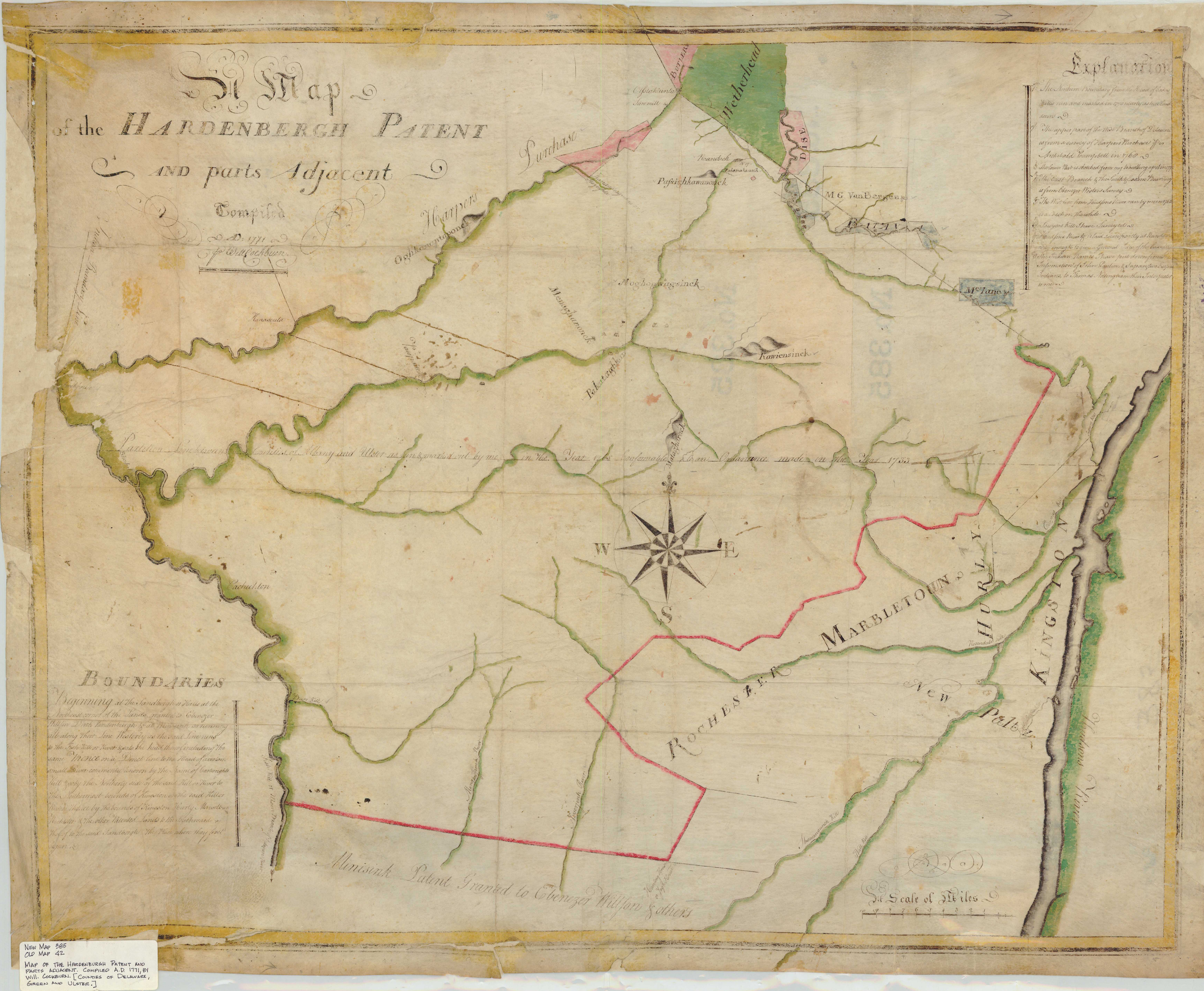
| A Map
of the Hardenbergh Patent
~ and parts Adjacent ~
Compiled ~ AD 1771 ~ Will Cockburn The original is held by the NYS Office of General Services, Corning Tower, Albany, New York It is Map No. 385. This map was rediscovered by Thomas Soja, see his research page:
|
 HardenberghPatentScan (larger) (full) |
Land Manager's MapChris Muscavage of Primitive Pieces brought up this fascinating map of the Hardenbergh Patent. We had it scanned by John Lorusso (parrotcolor.com) on his amazing flyover scanner.Here is a brief physical description of the map in question: A Map of the Hardenbergh Patent / granted in the year 1704 / Compiled and laid down from actual survey. N.p. but likely Kingston unsigned but attributed to William Cockburn, James Cockburn & Christopher Tappen, circa. 1790-92. Pen, ink & watercolor on laid paper, 16 joined sheets backed on original linen with silk selvage, 48â x 57â. De-ascension notation in manuscript at lower left corner of map "D H S / Ex I-3 / C M S Sept 17 1908â. Widespread flaking and losses affecting map and text, old restorations, modern verso stabilization, reinforced with Japan paper, selvage mostly preserved, exhibits evidence of being repeatedly handled over the centuries, old folds toned and chipped, map and text still very discernable and readable, good or better overall. Two similar manuscript maps of the patent located in New York State archives, one by William Cockburn 1770 and one by John Kiersted 1810, both of which are significantly smaller. No equivalent example located or identified. Auction records subsequent to 1900 indicate no similar map offered or sold. An exceptional and unique rarity. |
 1970 Catskill Land Map courtesy of Robert A. Burgher, Bureau of Real Property, New York State Department of Environmental Conservation
This is the description by Alf Evers:
Catskills Map. Published by the New York State Conservation Department, Albany, 1957. This map revised from earlier editions going back to 1899, shows patent and lot lines as well as subdivisions often as small as an individual farm. State-owned lands are indicated.
More info on the Catskill Land Map page!
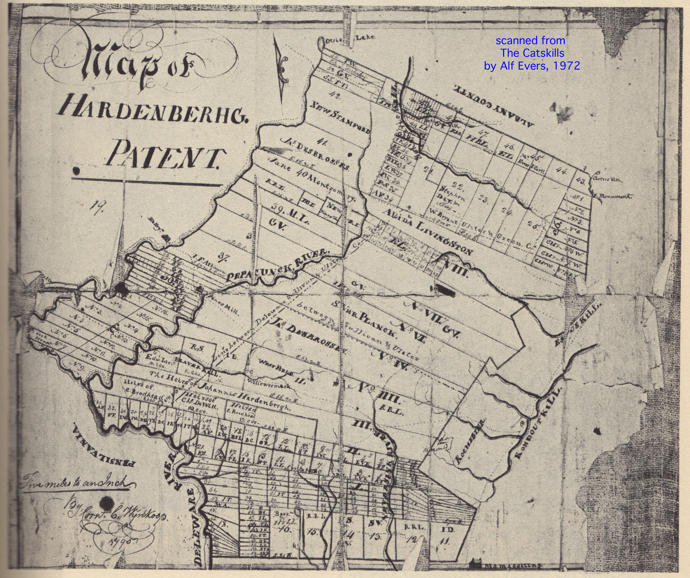 To the right is a map I scanned from
The Catskills: From Wilderness to Woodstock, by Alf Evers. This map of the Hardenbergh Patent was created by surveyor Cornelius C. Wynkoop in 1795.
To the right is a map I scanned from
The Catskills: From Wilderness to Woodstock, by Alf Evers. This map of the Hardenbergh Patent was created by surveyor Cornelius C. Wynkoop in 1795.
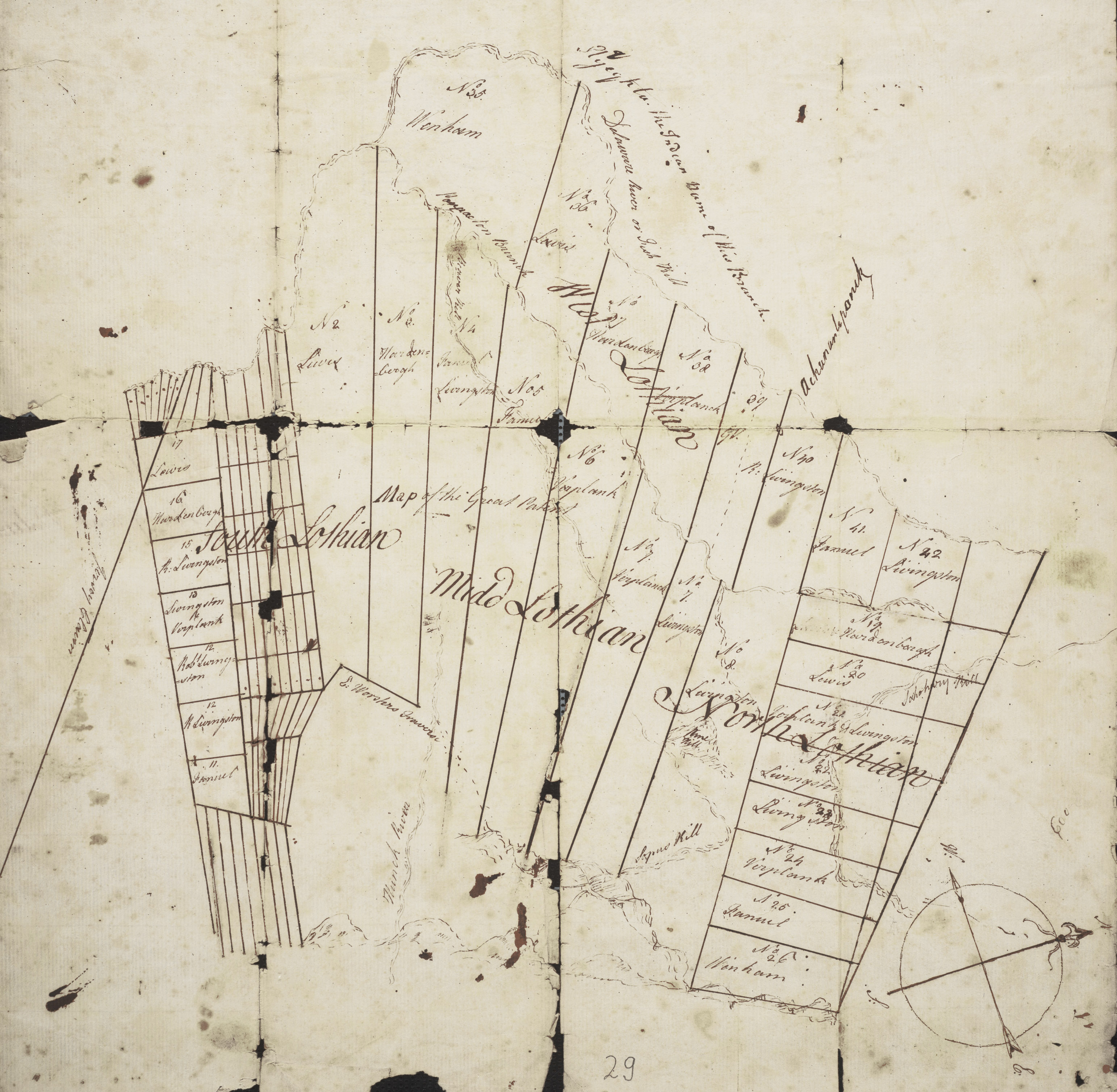
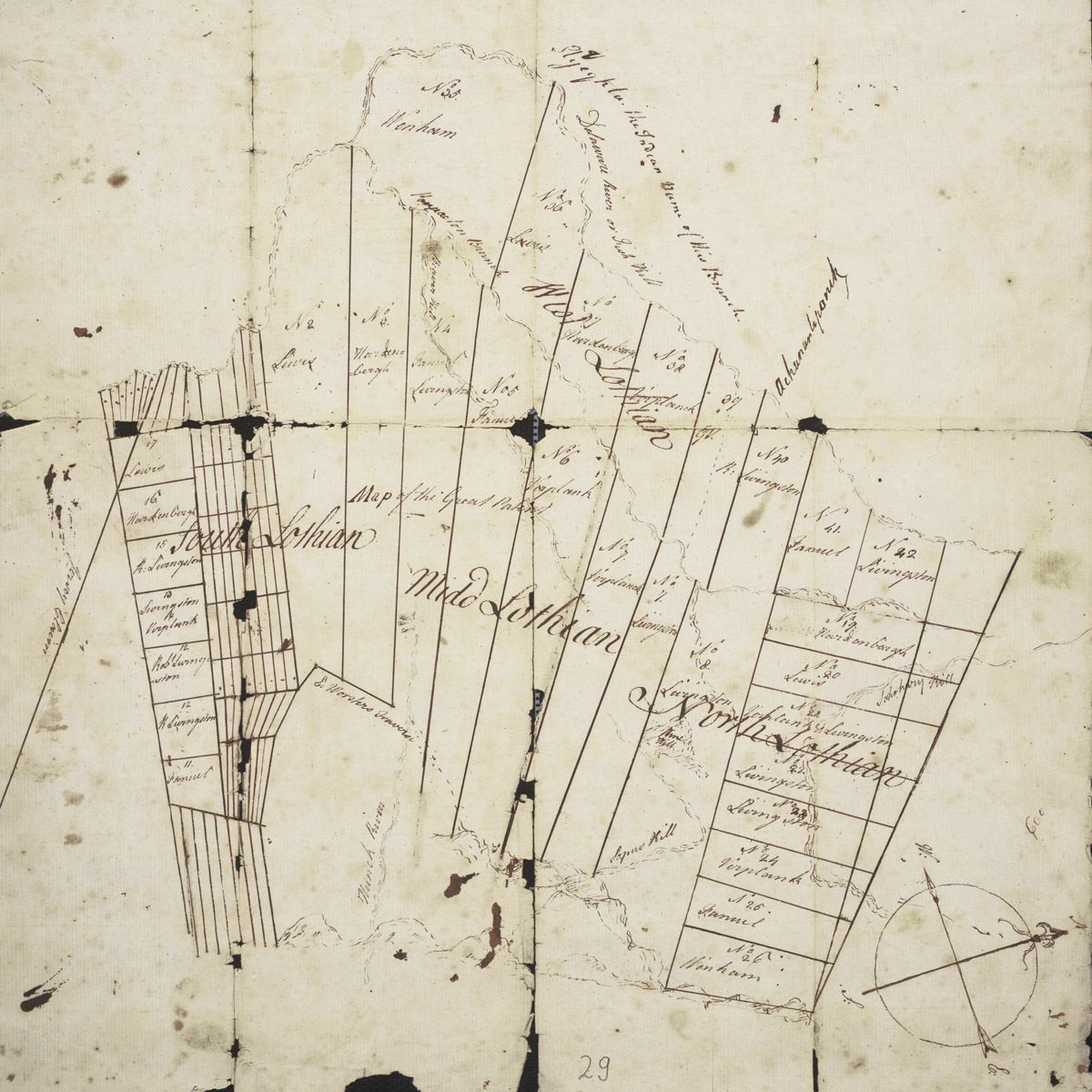 To the left is a map I got from the New York State Library's archive called the Cockburn Family Land Papers.
(hi-res)
To the left is a map I got from the New York State Library's archive called the Cockburn Family Land Papers.
(hi-res)
I was thinking this might be a draft map for map by William Cockburn, but, it appears to be quite a bit earlier. Perhaps is a study for the Wooster map.
It is interesting that it has Lothian on it. Wikipedia's Catskill History says Robert Livingston wanted to rename the Catkills to the Lothian Hills.
A contemporary view from Catskill Mountain News. Warning, this refers to Hardenbergh and his Cronies! - too bad it is gone! catskillmountainnews.com/content/a-catskill-catalog-march-24-2010
Links to the images for the text above, scanned from the Hardenbergh Family by author Myrtle Hardenbergh Miller - 3 images of text in 3 PDF files:
HardenberghPatent1.pdf,
HardenberghPatent2.pdf,
HardenberghPatent3.pdf
created 2012.02.24 <> updated 2025.11.15 <> YON <> hardenbergh.org/patent