February 27, 2025
Dear Mr. Hardenbergh,
Enclosed are certified copies of two different Maps of the Hardenbergh Patent that were drawn by Ebenezer Wooster in 1749 and of a related Deed of Agreement. I received them today from the NYS Archives in Albany.
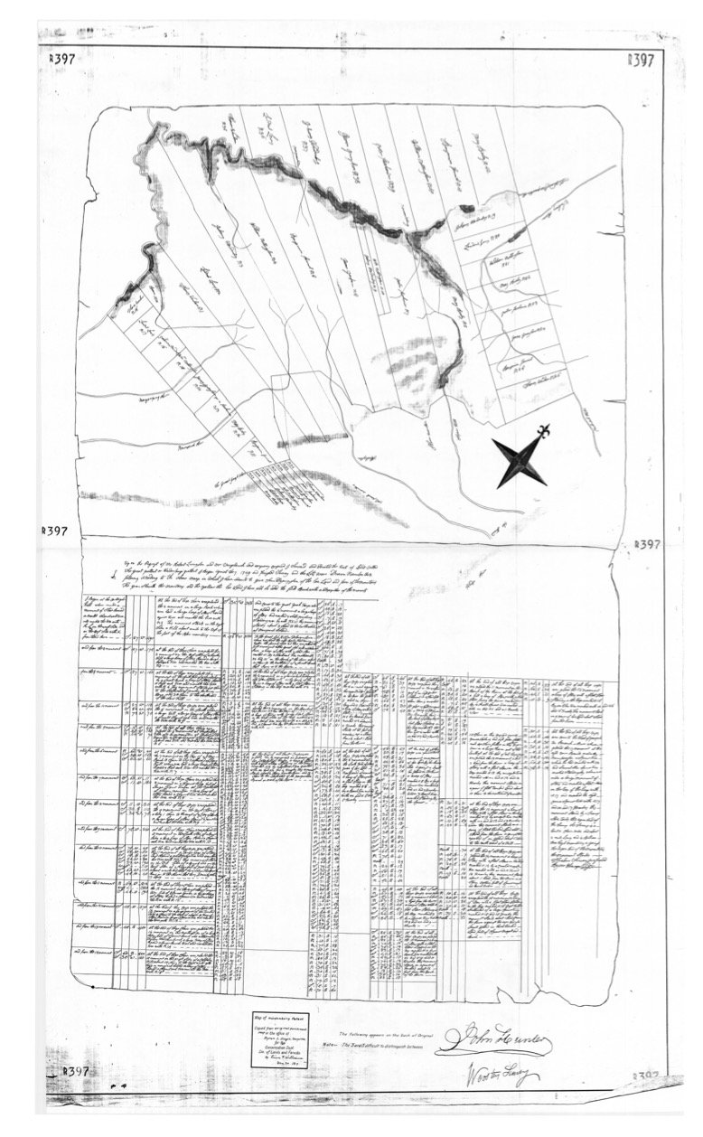
The first Map, to the right (NYSA_B2789-20_B1.pdf - hi-res PDF), depicts the original division of the Hardenbergh Patent into Great Lots and includes Field Notes by Wooster wherein he stated that, “Upon the Request of Mr Robert Livingston and Mr Verplank and company confirmed, I Servaid and Located the tract of land called The Great Pattent or Hardenbergh Pattent. I began April the 7th 1749 and finished Survey and the Lots were Drawn November the 8th following according to the above map in which I have endeavored to give sum Descriptshon of the Loe Land and the form of the Mountains. The green Showeth the Mountains and the yellow the Loe Land. I have all so added the Field Boock with a Descriptshon of the Monuments.”
Interestingly, even though the parties who authorized this survey (Livingston & Verplank) had previously acquired the ownership interests of patentees Nottingham, Graham, Fauconnier & Bickley through a series of Deeds made in 1741 & 1742, this Map does not identify them as the owners of Great Lots 4, 6, 7, 8, 10, 12, 13, 14, 15, 21, 22, 23, 24, 27, 30, 32, 33, 38, 39, 40 & 42. Perhaps they wanted to conceal the fact that they had acquired ownership of 50% of the Hardenbergh Patent.
Additionally, this Map has a major defect in that it does not depict the north-westerly boundaries of Great Lots 35 through 42. This defect shows that the Hardenbergh patentees overreached beyond the agreed boundaries of the Patent – beyond the true source of the Delaware River -- to the West Branch thereof – a stream not shown on this Map -- a stream that is only one-third of the size of the East Branch.
Since the Field Notes refer to the drawing of a lottery on November 8, 1749, I now describe it as the Wooster Map of that date. This Map and the accompanying Field Notes are located in NYS Archives Series B2789.
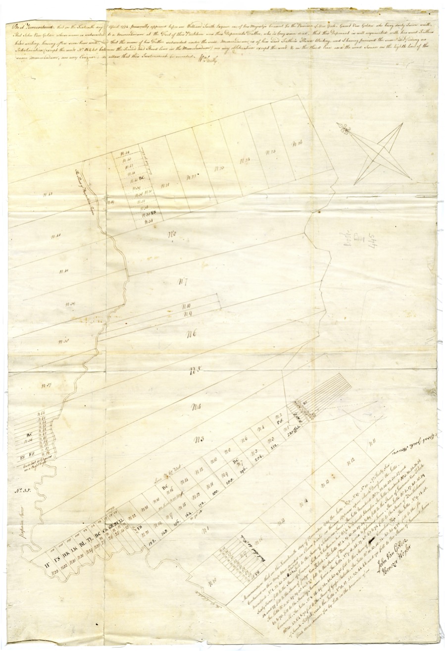
The second Map is attached to a Deed of Agreement dated November 23, 1749. [ hi-res PDF of deed and map ] This Map shows the entirety of the Hardenbergh Patent, plus portions of Great Lots 35 - 42, and depicts the subdivision of Great Lots 2, 17, 20 and 36 among the 11 heirs of Leonard Lewis, who was one of the original patentees. The lower right corner of this map contains the following: “Memorandum that on the Seventeenth of November 1749 the Lotts No. 2, No. 17, No. 20 & No. Thirty-Six Contained in this Map were divided in Eleven parts as thereon Appears upon which Division the Lotts Numbered No. 1, 22, 45, 33, 34, No. 56 & 68 fell to the Share of Johanna Freer. The Lots Numbered No. 2, 21, 55, 32, 35, 57 and Sixty Seven fell to the Share of Francis Filkins & Catherine his wife & Brandt Schuyler. The Lotts Numbered No. 3, 20, 54, 31, 36, 58 and 77 fell to the Share of Jaapie Van Kleek. The Lotts No. 4, 19, 53, 30, 37, 59 & 69 fell to the Share of Lawrence Van Kleek. The Lotts No. 5, 18, 47, 29, 38, 60 & 72 fell to the Share of Barendt Lewis & Johannes Lewis. The Lotts No. 6, 17, 48, 28, 39, 61 & 73 fell to the Share of Thomas Lewis. The Lotts No. 7, 16, 46, 27, 40, 62 & 74 fell to the Share of Bartholemew Crannell. The Lotts No. 8, 15, 49, 26, 41, 63 & 75 fell to the Share of Cornelia Kip. The Lotts No. 9, 14, 51, No. 25, 42, 64 & 71 fell to the Share of Geesje Roberts . The Lotts No. 10, 13, 50, 24, 43, 65 & 76 fell to the Share of Sarah Titshart and the Lotts No. 11, 12, 52, 23, 44, 66 and 70 fell to the Share of Leonard Lewis. And were drawn for by Lott in the Presence of us. John Van Gelder – Ebenezer Woster”
Since the aforesaid Memorandum refers to the drawing of a lottery on November 17, 1749, I now describe it as the Wooster Map of that date.
The accompanying Deed of Agreement was executed by the heirs of Leonard Lewis in favor of Bartholemew Crannell and states that, “Whereas upon a Subdivision of Lotts No. Two, No. Seventeen, No. Twenty & No. Thirty six lying in the Tract of Land granted to Hardenbergh and Company in Ulster and Albany Counties, the Lotts No. 7, 16, 46, 27, 40, 62 & 74 fell to the Share of Bartholemew Crannell, we whose Names are hereto subscribed and Seals affixed do hereby bind ourselves and Heirs to stand to the said Subdivision, And do promise to Join with the said Bartholemew Crannell his Heirs or Assigns in Executing Deeds of Partition according to the said Subdivision as by the Map thereof may appear. As Witness our Hands and Seals this 23rd of Nov. 1749. Tho Lewis {LS} Lawrence Van Kleek {LS} Jaapie Van Kleeck {LS} Isaac Kip {LS} Cornelia Kip {LS} Geesje Roberts {LS} Abraham Freer {LS} Joanna Freer {LS} Johannis Lewis {LS} Francis Filkins {LS} Catherine Filkins {LS} Barendt Lewis {LS} Witness John Van Gelder, Garrett Van Gelder.”
The Wooster Map of November 17, 1749 and the Deed of Agreement dated November 23, 1749 were both presented to William Smith, Esq., one of his Majesty’s Council for the Province of New York, on April 16, 1774. After comparing these to the originals, William Smith, Esq. allowed both of them to be officially recorded. (See the declarations … “Be it Remembered …” which are set forth at the top of the Map and near the middle of the Deed.) Thereafter, on April 20, 1774, they were examined and compared to the originals yet again by Deputy Secretary Sam Bayard, Jr. who also approved their recordation. (See the declaration at the bottom of the Deed.)
The Wooster Map of November 17, 1749 and the Deed of Agreement dated November 23, 1749 are located in Record of Deeds Volume 19 at Page 444. They are part of NYS Archives Series A0453.
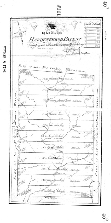
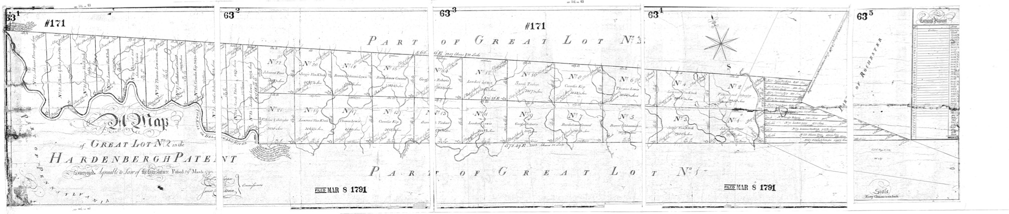
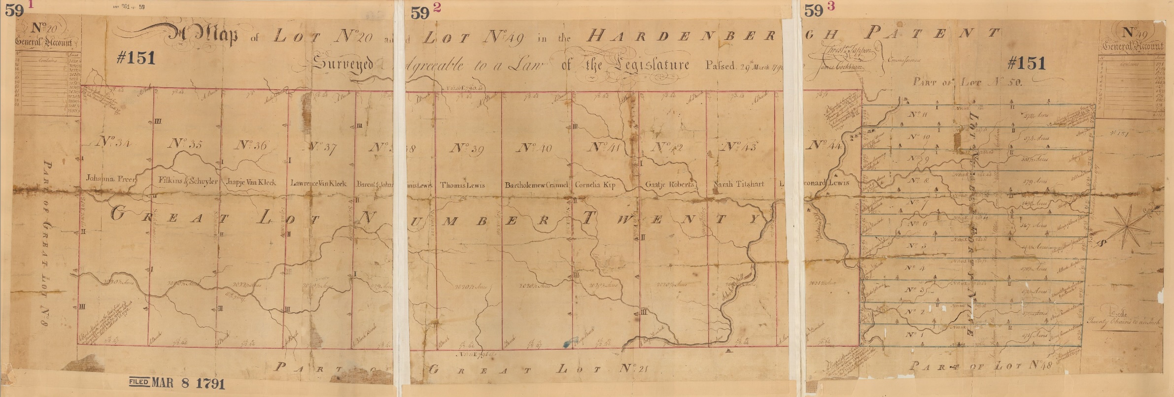
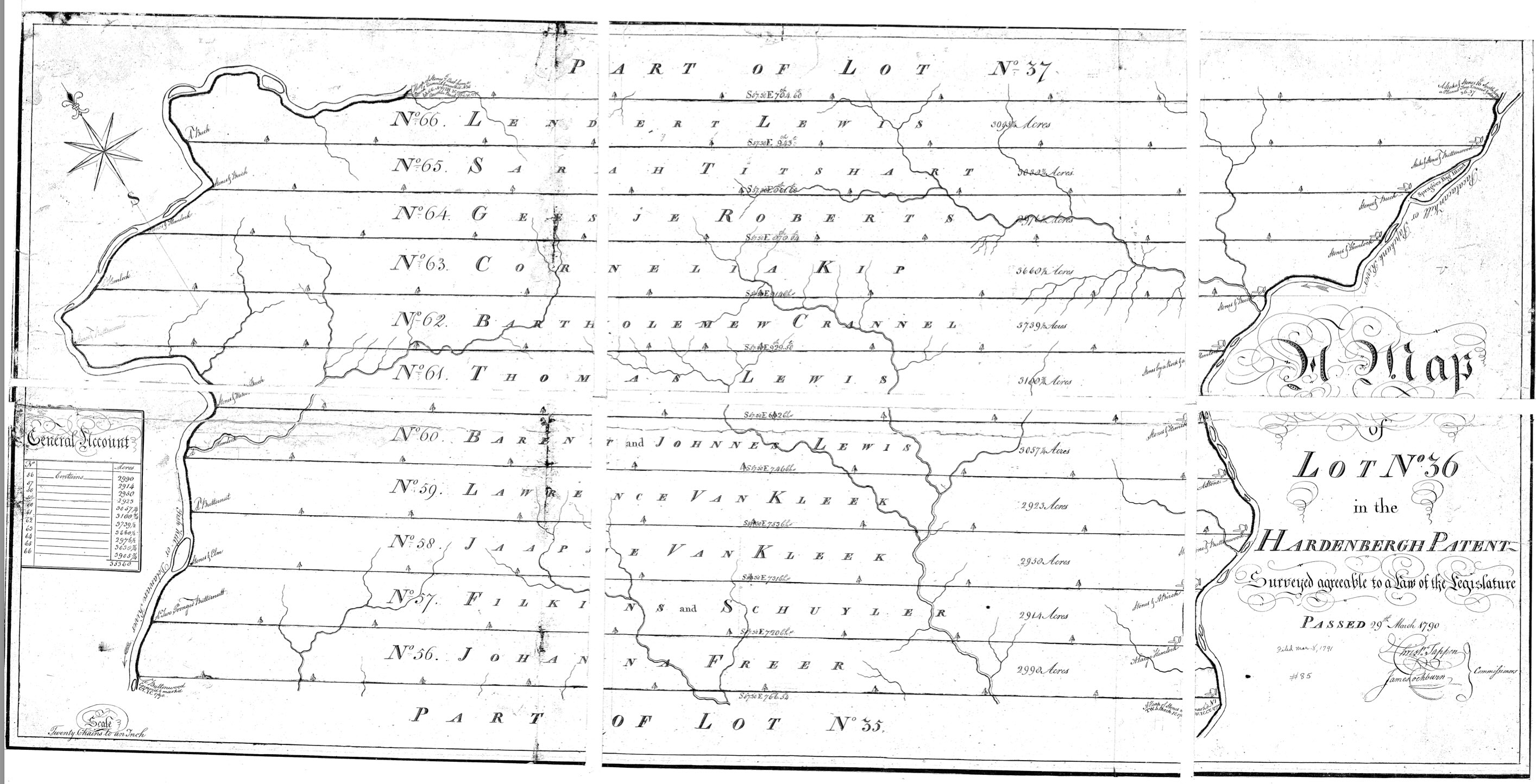
The obscure location of the Wooster Map of November 17, 1749 led to an error in the most comprehensive work to date on the Hardenbergh Patent, namely the booklet authored by Norman J. Van Valkenburgh in 1988. Mr. Van Valkenburgh was the Commissioner of the Real Property Bureau at the NYS Department of Environmental Conservation and therefore had access to a great many ancient maps, including the Wooster Map of November 8, 1749. However, when reading pp. 32-33 of his 1988 booklet, it becomes apparent that Mr. Van Valkenburgh was completely unaware of the Wooster Map dated November 17, 1749. I say that because Mr. Van Valkenburgh erroneously attributes the initial subdivision of Great Lots 2, 17, 20 & 36, and the creation of a perplexing lot numbering system, to surveys done by Christopher Tappan and James Cockburn pursuant to a law passed in 1790. The maps of those surveys were recorded by the Ulster County Clerk on March 8, 1791 as Map Nos. 171, 111, 151 and 85, respectively. In point of fact, a comparison of these 1791 survey maps to the Wooster Map of November 17, 1749 shows that the lot numbers match exactly.
This is not to say that these 1791 surveys were completely superfluous. The Wooster Map of November 17, 1749 does not depict the north-westerly boundary of Great Lot 36, namely the West Branch of the Delaware River. This glaring defect was resolved in the 1791 survey that was recorded by Ulster County as Map No. 85. Additionally, Great Lot 49 is not depicted in the Wooster Map of November 17, 1749 because it was created in 1751, after the north-easterly boundary of the Hardenbergh Patent had been adjusted. Great Lot 49 has a common boundary with Great Lot 20. Both of them are depicted in Ulster County Map No. 151.
I hope to convince the State Archivist to create a new series for the Wooster Map of November 17, 1749 and related Deed of Agreement dated November 23, 1749. Kindly post both of these Maps, the related Deed of Agreement, and the body of this cover letter, sans your address & my signature, online at Hardenbergh.org.
Dear Mr. Hardenbergh,
Attached to this email are images of each of the 1791 surveys mentioned in my letter. The first attachment is Great Lot 2 -- Ulster County Map No. 171. (image links to hi-res PDF)
The second is Great Lot 17 – Ulster County Map No. 111. See vertical above and hi-res PDF.
The third is Great Lots 20 & 49 – Ulster County Map No. 151. (image links to hi-res PDF)
The fourth attachment is Great Lot 36 – Ulster County Map No. 85. (image links to hi-res PDF)
The title of the 1988 booklet by Norman J. Van Valkenburgh is: The Hardenburgh Patent – The Largest Colonial Patent. Hardenb?rgh?
I first learned of this booklet about 20 years ago when reading a comprehensive work issued by Delaware County. However, no one in the Clerk’s office or anywhere else could find a copy of it. I even contracted the Purple Mountain Press, which had originally published the 1988 booklet, only to learn that it is out-of-print. About 10 years ago, I met a distant cousin of Mr. Van Valkenburgh who said that she might be able to get a copy of it, but never did. I searched online for this booklet yet again a few months ago hoping to find it on Amazon or eBay. No luck there – but better yet -- I found that it has been republished by the New York State Association of Professional Land Surveyors. I got my copy within a few days after ordering it online at www.nysapls.org